San Andreas Fault Analysis At Wallace Creek
Holbox
Mar 19, 2025 · 7 min read
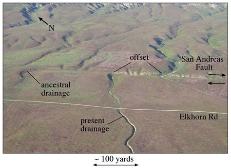
Table of Contents
San Andreas Fault Analysis at Wallace Creek: A Deep Dive into Tectonic Activity
The San Andreas Fault, a continental transform fault extending roughly 800 miles through California, is a prime example of the Earth's dynamic nature. Understanding its behavior is crucial for mitigating seismic hazards and predicting future earthquakes. Wallace Creek, a location situated directly across the fault, provides a unique opportunity to analyze the fault's complex interactions with the surrounding landscape. This in-depth analysis delves into the geological features, historical seismic activity, and ongoing research efforts at Wallace Creek, offering a comprehensive understanding of this critical area along the San Andreas Fault.
The Geological Setting of Wallace Creek
Wallace Creek is strategically positioned within the Carrizo Plain section of the San Andreas Fault, a region characterized by its relatively straight and simple geometry. This contrasts with other sections of the fault, which are often more complex due to bends and offsets. The straightforward nature of the fault at Wallace Creek simplifies analyses and offers a clearer picture of the fault's movement. The area's exposed geology, featuring relatively recent alluvial deposits and bedrock formations, allows for detailed study of fault scarps, offsets, and other surface manifestations of tectonic activity.
Fault Scarps and Offsets
A prominent feature at Wallace Creek is the presence of distinct fault scarps. These scarps, which are essentially cliffs formed by the vertical displacement of the Earth's surface along the fault line, provide direct evidence of the fault's cumulative displacement over time. By analyzing the height and morphology of these scarps, geologists can estimate the rate of fault slip and the timing of past seismic events. Precise measurements of offset features, such as stream channels and alluvial fans, further refine these estimations. The detailed mapping of these offsets helps scientists create a detailed picture of fault movement and the long-term behavior of the San Andreas Fault.
Alluvial Deposits and Their Significance
The alluvial deposits surrounding Wallace Creek offer valuable clues about the history of the fault's activity. These sediments, accumulated over millennia by the creek, have been repeatedly displaced and deformed by fault movements. By analyzing the layers of sediment, particularly the ages and characteristics of various strata, researchers can reconstruct the timing and magnitude of past earthquakes. The presence of deformed or disrupted sediment layers indicates periods of intense seismic activity, helping create a chronological timeline of earthquakes impacting the Wallace Creek area. Radiocarbon dating of organic materials within these deposits provides particularly valuable chronological constraints.
Bedrock Geology and Fault Interactions
The bedrock formations underlying Wallace Creek also play a significant role in shaping the fault's behavior. The type of rock, its strength, and its structural orientation influence the way the fault propagates and ruptures. Understanding the interaction between the fault and the surrounding bedrock is crucial for accurately modeling earthquake rupture and predicting future seismic events. Studies of the bedrock's composition and structure at Wallace Creek provide essential insights into the fault's overall behavior and the potential for large-scale earthquakes.
Historical Seismic Activity at Wallace Creek
The Wallace Creek area falls within a seismically active zone along the San Andreas Fault. While detailed instrumental records are relatively recent, paleoseismic studies – investigations of past earthquake activity through geological evidence – have revealed a long history of significant earthquakes affecting this region.
Paleoseismic Investigations
Paleoseismic investigations at Wallace Creek involve carefully excavating trenches across the fault to expose the subsurface stratigraphy. These trenches provide cross-sections of the sedimentary layers and reveal evidence of past fault rupture events. Displaced layers, liquefaction features (evidence of ground shaking causing saturated sediments to behave like a liquid), and other geological indicators are used to identify and characterize past earthquakes. The depth and extent of these features are used to estimate the magnitude and recurrence intervals of earthquakes in the area.
Determining Recurrence Intervals
By analyzing the sedimentary record and identifying multiple earthquake events, scientists can determine the recurrence intervals – the average time between successive earthquakes of a certain magnitude – at Wallace Creek. This information is critical for probabilistic seismic hazard assessments, which evaluate the likelihood of future earthquakes and the associated risks. Understanding recurrence intervals is essential for developing building codes, infrastructure planning, and emergency preparedness strategies in the region.
Linking Geological Records to Historical Accounts
Although historical accounts of earthquakes in this specific area might be limited, paleoseismic studies can be compared with more broadly regional historical records. This can provide a broader context for the magnitudes and impact of earthquakes in the Wallace Creek area, even in the absence of detailed local records. By correlating the geological findings with regional seismic patterns, researchers can further refine their understanding of the earthquake history in this critical section of the San Andreas Fault.
Ongoing Research and Future Directions
Research at Wallace Creek continues to improve our understanding of the San Andreas Fault's behavior. Several ongoing projects are focusing on refining various aspects of fault analysis, contributing to more accurate hazard assessments and improved earthquake preparedness.
Advanced Geophysical Techniques
Geophysical techniques, such as ground-penetrating radar (GPR) and magnetotellurics (MT), are increasingly used to image the subsurface structure of the fault zone at Wallace Creek. These non-invasive methods provide high-resolution images of the fault's geometry and its interaction with the surrounding geology, providing a more detailed and complete picture than traditional trenching methods alone. Analysis of these geophysical data enhances our understanding of fault complexity and potential rupture scenarios.
Modeling Earthquake Rupture
Sophisticated computer models are being developed to simulate earthquake rupture along the San Andreas Fault. These models incorporate data from geological investigations, geophysical surveys, and historical seismic records to simulate the propagation of seismic waves during an earthquake. These models help predict the ground motion expected in the Wallace Creek area during future earthquakes, informing building codes and emergency response planning.
Geodetic Monitoring
Geodetic measurements, using techniques like GPS and InSAR (Interferometric Synthetic Aperture Radar), are used to monitor ground deformation along the San Andreas Fault. This data provides real-time information on the fault's movement, allowing researchers to detect subtle changes in strain accumulation and potentially identify areas at higher risk of future rupture. This continuous monitoring helps improve early warning systems and provide valuable insights into the dynamics of the fault.
Integrating Multiple Data Sources
One of the most significant advances in San Andreas Fault research is the integration of multiple data sources. Combining geological, geophysical, geodetic, and historical data allows for a more holistic understanding of the fault's behavior. By integrating these diverse datasets, researchers can create more comprehensive and accurate models, improving the reliability of seismic hazard assessments and enhancing our ability to prepare for future earthquakes.
Conclusion: The Importance of Wallace Creek Studies
The San Andreas Fault at Wallace Creek serves as a critical site for understanding the complex dynamics of a major transform fault. The area’s accessible geology, combined with ongoing research utilizing advanced techniques, provides valuable insights into the fault's behavior, including its history of seismic activity, recurrence intervals, and the potential for future earthquakes. This knowledge is fundamental to mitigating seismic hazards and developing effective strategies for earthquake preparedness in California and beyond. Continued research at Wallace Creek and similar locations along the San Andreas Fault is essential for improving our understanding of this powerful geological force and for protecting communities from the devastating effects of future earthquakes. The detailed study of fault scarps, alluvial deposits, and bedrock interactions, combined with advanced geophysical and geodetic monitoring, allows for increasingly accurate earthquake hazard assessments and more effective strategies for mitigating risk in the region. The importance of this research cannot be overstated in terms of protecting lives and infrastructure. Wallace Creek, therefore, stands as a vital site for ongoing geological investigations, contributing significantly to our understanding and preparedness for future seismic events along this iconic fault.
Latest Posts
Latest Posts
-
Which Of The Following Is An Eoc Function
Mar 19, 2025
-
The Real Interest Rate Tells You
Mar 19, 2025
-
Predict The Product For The Reaction Shown
Mar 19, 2025
-
Real Time Physics Lab 7 Homework Answers
Mar 19, 2025
-
What Do Sutures Gomphoses And Syndesmoses Have In Common
Mar 19, 2025
Related Post
Thank you for visiting our website which covers about San Andreas Fault Analysis At Wallace Creek . We hope the information provided has been useful to you. Feel free to contact us if you have any questions or need further assistance. See you next time and don't miss to bookmark.
