Why Are The Sedimentary Layers At Capitol Reef Tilted
Holbox
Mar 17, 2025 · 6 min read
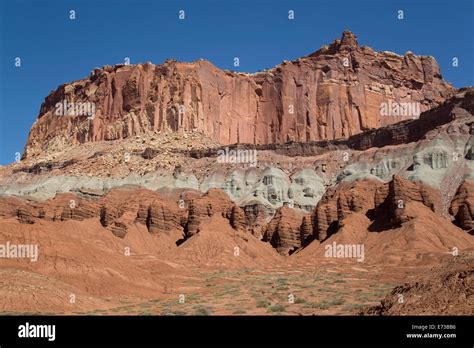
Table of Contents
Why Are the Sedimentary Layers at Capitol Reef National Park Tilted?
Capitol Reef National Park, a breathtaking expanse of colorful cliffs and sculpted canyons in Utah, is renowned for its dramatic tilted sedimentary layers. These aren't random formations; they tell a compelling story of millions of years of geological activity, shaped by powerful forces that sculpted the landscape we see today. This article delves into the fascinating reasons behind the tilted strata, exploring the processes of sedimentation, tectonic uplift, and erosion that have combined to create this geological marvel.
Understanding Sedimentary Layers: A Foundation in Time
Before understanding why the layers are tilted, it's crucial to grasp how they formed in the first place. Sedimentary rocks are formed through a process called sedimentation. This involves the accumulation of sediment—particles of sand, silt, clay, and organic matter—over vast periods. These sediments are transported by wind, water, and ice, eventually settling and compressing under their own weight. Over millions of years, this pressure, along with the cementation of minerals between particles, solidifies the sediment into rock layers. Each layer represents a distinct period in geological history, recording changes in climate, sea level, and the environment. The Capitol Reef area, over eons, experienced variations in depositional environments, resulting in the distinctive layering of sandstone, shale, and limestone that we observe today. These layers, originally laid down horizontally, provide a record of past environments, each unique in its composition and texture. The presence of fossils within certain layers can further illuminate the age and environmental conditions present during deposition.
The Significance of Horizontal Layering
A key principle in geology is the Principle of Original Horizontality. This states that sedimentary layers are initially deposited horizontally. Any deviation from this horizontal orientation indicates subsequent geological events that have disturbed the original layering. This is precisely what we observe at Capitol Reef: the dramatic tilting of these once-horizontal layers. Understanding this principle is fundamental to interpreting the geological history of the park.
Tectonic Forces: The Driving Force Behind the Tilt
The dramatic tilting of the sedimentary layers at Capitol Reef is primarily attributed to tectonic activity. Tectonic plates, the massive segments of Earth's lithosphere, are constantly in motion, driven by powerful forces within the Earth's mantle. The collision and movement of these plates lead to uplift, faulting, and folding of the Earth's crust, dramatically altering the landscape.
The Waterpocket Fold: A Masterpiece of Tectonic Uplift
The most prominent feature responsible for the tilted layers at Capitol Reef is the Waterpocket Fold. This is a massive monocline, a large-scale bend in rock layers that resembles a wrinkle in a rug. This fold, stretching for approximately 100 miles, was formed by the compressional forces exerted during the Laramide Orogeny, a period of intense mountain building that occurred in the Late Cretaceous and Early Paleogene periods (approximately 80-40 million years ago).
The exact mechanics of the Waterpocket Fold's formation are complex and still under investigation, but the prevailing theory suggests that the compressional forces pushed the rock layers upward, creating this spectacular fold. The forces weren't uniformly distributed, resulting in the varying degrees of tilt observed across the fold. Some areas exhibit steeper dips, while others show gentler slopes, reflecting the intricacies of the tectonic forces involved.
Understanding the Laramide Orogeny
The Laramide Orogeny significantly impacted the western United States, leading to the uplift of the Rocky Mountains and numerous other mountain ranges. This period of tectonic activity was unique in that it produced relatively low-angle thrust faults, causing broad uplifts rather than sharp, high mountain ranges. This is why the Waterpocket Fold is a broad, gentle fold rather than a sharp, dramatic mountain range. The compressional forces associated with this orogeny exerted considerable pressure on the sedimentary layers, resulting in their dramatic tilting and the formation of the Waterpocket Fold.
Erosion: Sculpting the Landscape
While tectonic forces created the initial tilt, erosion played a crucial role in shaping the landscape we see today. Over millions of years, wind, water, and ice have relentlessly eroded the uplifted rock layers, sculpting the canyons, cliffs, and domes that characterize Capitol Reef.
Differential Erosion: Uneven Wear and Tear
Differential erosion is a key process that explains the varying landscape features. Different rock types erode at different rates. For example, harder, more resistant rocks like sandstone tend to erode more slowly than softer rocks like shale. This differential erosion leads to the formation of distinct features, such as cliffs formed by resistant layers and canyons carved out of less resistant layers. The tilted layers further enhance this differential erosion, creating the unique and dramatic topography of the park.
The Role of Water in Shaping the Landscape
Water, in its various forms, plays a significant role in shaping the landscape. Rainfall, streams, and flash floods erode the softer rocks, carving out canyons and creating the intricate drainage patterns observed throughout the park. The Fremont River, flowing through the park, has played a crucial role in shaping the landscape, carving its way through the tilted layers and creating stunning canyons.
The Ongoing Story: A Dynamic Landscape
It's essential to remember that the geological processes shaping Capitol Reef are not finished. The area continues to be subtly affected by tectonic activity and erosion. Although the rate of change is slow compared to the human timescale, the landscape is dynamically evolving. The ongoing processes of uplift, erosion, and weathering ensure that Capitol Reef will continue to be a stunning testament to Earth's power and the wonders of geological time.
Exploring the Tilted Layers: A Deeper Dive into Specific Locations
Several specific locations within Capitol Reef National Park vividly demonstrate the tilted sedimentary layers and the geological processes that created them:
Goosenecks Overlook: A Panoramic View of the Fold
Goosenecks Overlook provides a breathtaking panoramic view of the Waterpocket Fold. From this vantage point, the immense scale of the fold becomes readily apparent, showcasing the dramatic tilting of the layers across a vast expanse. The different colors and textures of the layers are clearly visible, emphasizing the variations in rock composition and depositional environments.
Capitol Gorge: A Walk Through Tilted Time
Capitol Gorge offers a unique opportunity to walk through the tilted layers. The trail meanders through the gorge, revealing the different rock formations up close. The varying degrees of tilt and the erosion patterns are readily observable, providing a tangible experience of the geological forces that shaped the landscape.
Hickman Bridge: A Natural Arch Formed by Erosion
Hickman Bridge, a stunning natural arch, is another example of erosion's power in shaping the landscape. The arch formed as a result of differential erosion, with softer rocks eroding faster than the more resistant sandstone that forms the bridge. The bridge's location within the tilted layers further demonstrates the interplay between tectonic activity and erosion.
Conclusion: A Legacy of Geological Processes
The tilted sedimentary layers at Capitol Reef National Park stand as a powerful testament to millions of years of geological processes. The combination of horizontal sedimentation, tectonic uplift during the Laramide Orogeny, and subsequent erosion have resulted in the dramatic and visually stunning landscape we see today. Understanding the geological history of this area provides a profound appreciation for the dynamic nature of Earth's processes and the intricate story etched into the rocks. The park serves as an open-air geological textbook, offering a captivating glimpse into deep time and the ongoing shaping of our planet. Further research and exploration will undoubtedly continue to reveal new insights into the intricate geological history of this remarkable national park. Its tilted layers remain a compelling invitation to delve deeper into the fascinating world of geology, inspiring awe and wonder in all who visit.
Latest Posts
Latest Posts
-
Choose All That Are Characteristics Of Neural Pools
Mar 17, 2025
-
The Two Topics Of Primary Concern In Macroeconomics Are
Mar 17, 2025
-
A Toy Rocket Is Launched Vertically From Ground Level
Mar 17, 2025
-
Experiment 34 An Equilibrium Constant Pre Lab Answers
Mar 17, 2025
-
The Preferred Way To Avoid An Ethnocentric Perspective Is To
Mar 17, 2025
Related Post
Thank you for visiting our website which covers about Why Are The Sedimentary Layers At Capitol Reef Tilted . We hope the information provided has been useful to you. Feel free to contact us if you have any questions or need further assistance. See you next time and don't miss to bookmark.
