Table 1. Earthquake Triangulation Via Three Seismograph Stations
Holbox
Mar 27, 2025 · 6 min read
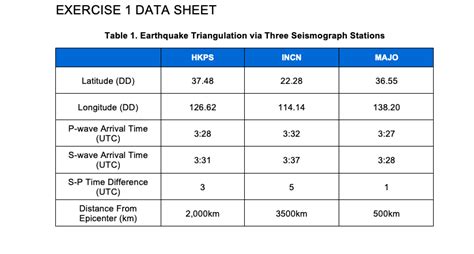
Table of Contents
- Table 1. Earthquake Triangulation Via Three Seismograph Stations
- Table of Contents
- Earthquake Triangulation via Three Seismograph Stations: A Comprehensive Guide
- Understanding Seismic Waves and Arrival Times
- Utilizing the P-wave and S-wave Velocity Difference
- The Principle of Triangulation
- Refining the Location: The Intersection Area
- Practical Aspects of Earthquake Triangulation
- Beyond Three Stations: Improving Accuracy
- Advanced Techniques and Data Integration
- Applications and Significance of Earthquake Triangulation
- Conclusion: A Continuous Evolution
- Latest Posts
- Latest Posts
- Related Post
Earthquake Triangulation via Three Seismograph Stations: A Comprehensive Guide
Earthquakes, those sudden and violent movements of the Earth's crust, are a powerful reminder of the dynamic nature of our planet. Understanding their origin, magnitude, and impact is crucial for mitigating their devastating consequences. A fundamental technique used in seismology to locate the epicenter of an earthquake is triangulation, employing data from at least three seismograph stations. This article delves deep into the principles, process, and practical considerations of earthquake triangulation using three seismograph stations.
Understanding Seismic Waves and Arrival Times
Before exploring triangulation, it's essential to grasp the basics of seismic waves. Earthquakes generate several types of waves, but the primary ones used for location determination are P-waves (primary waves) and S-waves (secondary waves). P-waves are compressional waves, meaning they travel by compressing and expanding the material they pass through. They are faster than S-waves. S-waves, on the other hand, are shear waves, traveling by shearing or shaking the material perpendicular to their direction of propagation.
The difference in arrival times between P-waves and S-waves at a seismograph station is crucial. This time difference, often denoted as Δt (delta t), is directly related to the distance between the seismograph station and the earthquake's epicenter. The farther the station is from the epicenter, the greater the time difference between the arrival of the P-wave and the S-wave. This relationship is based on the known difference in the velocities of P-waves and S-waves within the Earth's crust.
Utilizing the P-wave and S-wave Velocity Difference
The velocity of P-waves (Vp) and S-waves (Vs) in a specific geological region is relatively constant. This allows seismologists to establish a relationship between the distance (d) to the epicenter and the time difference (Δt) using a simple formula:
d = VpVs/(Vp - Vs) * Δt
This formula provides the distance to the epicenter, but not its precise location. This is where triangulation comes in.
The Principle of Triangulation
Triangulation leverages the distances determined from multiple seismograph stations. Imagine three seismograph stations (A, B, and C) receiving signals from the same earthquake. Each station records the arrival times of P-waves and S-waves, allowing the calculation of the distance to the epicenter using the formula above. This provides three distances (dA, dB, and dC).
Each distance represents a circle with the seismograph station at its center and the calculated distance as its radius. The epicenter of the earthquake lies at the intersection of these three circles. In reality, due to slight inaccuracies in timing and velocity estimations, the circles won't perfectly intersect at a single point. Instead, they form a small area where the epicenter is most likely located.
Refining the Location: The Intersection Area
The intersection area provides a probable range for the earthquake's epicenter. The size of this area reflects the accuracy of the measurements and the uncertainties involved. Several factors contribute to the size of this area, including:
- Accuracy of arrival time readings: Even minor errors in reading the arrival times can significantly affect the calculated distances and the intersection area.
- Variations in seismic wave velocities: The assumed velocities of P-waves and S-waves might not be perfectly uniform throughout the Earth's crust in the region, introducing inaccuracies.
- Complexity of seismic wave propagation: Seismic waves can reflect and refract as they travel through the Earth, leading to variations in arrival times that are not accounted for in simplified models.
Practical Aspects of Earthquake Triangulation
The process of earthquake triangulation involves several key steps:
-
Data Acquisition: Seismograph stations across a region continuously monitor seismic activity. When an earthquake occurs, the stations record the arrival times of P-waves and S-waves. This data is meticulously recorded and time-stamped, often with high precision.
-
Arrival Time Determination: Trained seismologists analyze the seismograms (the records produced by seismographs) to determine the exact arrival times of the P-waves and S-waves. This process requires expertise and careful attention to detail, as the accuracy of the arrival time readings directly impacts the accuracy of the epicenter location.
-
Distance Calculation: Using the formula mentioned above and the known P-wave and S-wave velocities for the region, the distance to the epicenter from each station is calculated. Modern seismological software automates this step, enhancing speed and efficiency.
-
Triangulation and Epicenter Determination: The calculated distances are used to draw circles on a map centered on each seismograph station. The intersection of these circles provides the estimated location of the earthquake's epicenter. Advanced computer programs utilize sophisticated algorithms to refine the intersection area and improve accuracy.
-
Error Analysis and Refinement: Seismologists analyze potential sources of error and refine the epicenter location. This includes considering variations in seismic wave velocities, instrument errors, and complexities in wave propagation. Advanced techniques often incorporate multiple stations beyond the minimum three to reduce uncertainties.
Beyond Three Stations: Improving Accuracy
While three stations are sufficient for triangulation, using more stations significantly improves the accuracy and reliability of the epicenter determination. Additional stations provide redundant data, allowing for a more robust estimation of the location by minimizing the effect of errors from individual stations. The greater the number of stations, the smaller the intersection area and the more precise the epicenter location.
Advanced Techniques and Data Integration
Modern seismological practice involves integrating data from a large network of stations and employing sophisticated computer algorithms. These algorithms use statistical methods to weigh the data from different stations, minimize errors, and provide a more reliable estimate of the epicenter's location, depth, and magnitude.
Applications and Significance of Earthquake Triangulation
Precisely locating earthquakes is crucial for numerous applications:
-
Hazard Assessment: Knowing the location and magnitude of earthquakes helps assess the risk in different regions and inform building codes and disaster preparedness plans.
-
Tsunami Warnings: Quick and accurate location determination is vital for timely tsunami warnings, allowing coastal communities to evacuate and minimize casualties.
-
Geological Studies: Earthquake locations provide valuable insights into tectonic plate boundaries, fault lines, and the Earth's internal structure. Patterns in earthquake distribution reveal valuable information about geological processes and dynamics.
-
Scientific Research: Precise earthquake location data is fundamental to various research areas, including studying earthquake mechanisms, understanding seismic wave propagation, and developing improved earthquake prediction models.
-
Engineering and Infrastructure: Accurate earthquake locations inform the design of earthquake-resistant infrastructure, helping to minimize damage during seismic events.
Conclusion: A Continuous Evolution
Earthquake triangulation using three seismograph stations represents a foundational technique in seismology. While the basic principle remains the same, advancements in technology, data analysis techniques, and computational power have significantly improved the accuracy and efficiency of locating earthquakes. The integration of numerous stations and sophisticated algorithms has pushed the boundaries of seismic location determination, transforming our understanding of earthquakes and supporting critical applications in hazard mitigation and scientific discovery. The continuous development and refinement of these techniques are crucial in improving our ability to monitor, understand, and prepare for future seismic events, safeguarding lives and infrastructure.
Latest Posts
Latest Posts
-
You Have Important Time Sensitive Information
Mar 31, 2025
-
Liquid Sodium Is Being Considered As An Engine Coolant
Mar 31, 2025
-
A Runner Runs Around The Track At A Constant Speed
Mar 31, 2025
-
Cause Of Doody Out Of Business
Mar 31, 2025
-
You Should In Order To Document Data Properly
Mar 31, 2025
Related Post
Thank you for visiting our website which covers about Table 1. Earthquake Triangulation Via Three Seismograph Stations . We hope the information provided has been useful to you. Feel free to contact us if you have any questions or need further assistance. See you next time and don't miss to bookmark.
